Survey Lab’s services includes:
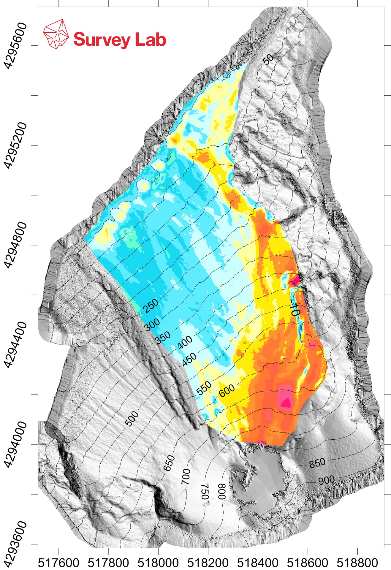
Geomatic monitoring of structure, infrastructure and cultural heritage - Survey Lab provides services to monitor historical-architectural, infrastructure, and facilities, based on the use of data acquired through SAR (Synthetic Aperture Radar) satellite methodology and its integration with ground-based measurements. The acquired data constitutes the basis for the development of numerical models that describe the behaviour of the investigated structures.
Land Monitoring - Survey Lab designs and implements systems for land monitoring at small and large scale through the integration of geomatics ground-based sensors and observation systems operating on aerial and satellite platforms.
Database for infrastructure management - Survey Lab takes a census of the infrastructure networks by means of GNSS survey methods, and constructs/populates georeferenced dynamic database usable and accessible in the most common GIS platforms, with precision techniques for real-time positioning and instrumentation for the acquisition of the ancillary parameters, based on the user requirements.
High precision surveying - Survey Lab designs, manufactures and surveys high-precision topographic networks through high-performance instrumentation to support large scale scientific installations and infrastructure that need to be placed into a reference frame with the greatest precision.
Three-dimensional modelling - Survey Lab provides a reverse engineering service using high-precision measurement methods via laser scanner and digital photogrammetry and takes advantage of its three-dimensional modelling experts.
The company’s core service is I.MODI, an operational prevention and investigation tool, aimed at monitoring medium-long term buildings and infrastructures. This product was born during the incubation in the ESA-BIC Lazio from 2013 to 2015, but it was developed thanks the H2020 SME Instrument Phase II funding obtained from 2016 to 2018. Now it is in the commercialization phase.
I.MODI (Implemented MOnitoring system for structural DIsplacement) is a value added service, co-funded by the European programme H2020, that integrates Earth Observation technologies, ground based data and ICT to develop services for monitoring the stability of buildings in large urban areas and for controlling critical civil infrastructures. The aim of I.MODI project is the development of a service that fully employs Earth Observation (EO) data into standard procedures, devoted to structural damage assessment, thus contributing to implement mitigation and prevention actions for potential failures.


