
Other Offices in Italy
Contrada Terlecchie, snc 75100 Matera
e-GEOS, an ASI (20%) / Telespazio (80%) company, is a leading AN ASI / TELESPAZIO COMPANY international player in the Earth Observation and Geo-Spatial Information business.
e-GEOS, an ASI (20%) / Telespazio (80%) company subject to the joint direction and coordination of Leonardo S.p.A and Thales S.A, is a leading international player in the Earth Observation (EO) and Geo-Spatial Information business offering a unique portfolio of application services. e-GEOS is the exclusive global distributor for the COSMO-SkyMed data of first and second generation, the most advanced and performing Radar Satellite constellation available today. Thanks to the superior monitoring capabilities of the COSMO-SkyMed constellation and the fusion with a broad range of EO and non-EO data, e-GEOS has become one of the global leaders in geospatial services and is leading the evolution to GeoInformation digital services through CLEOS, its digital market place, and the application platforms by verticals.
The Matera Space Centre is dedicated to Earth Observation and Space Geodesy. At the Centre e-GEOS acquires, processes, stores and distributes remote sensing data from the main Earth observation satellites, and produces images, products and services in near real-time for maritime surveillance. In 2012, the Matera Space Centre was included in the Core Ground Segment of the European Space Agency (ESA) within Copernicus.
e-GEOS runs a multi-purpose 24h Emergency Room and Mapping Centre that is able to work all-year-round with a 24 hours availability; Today these services are offered to both institutional and civilian customers like: European Copernicus Program (EMS) a main success cases, Copernicus SEA (Copernicus services in Support to EU External Action) the IMINT reports service for Defence and Intelligence.
From pixels to digital services – geoinformation into the platform economy:
- SEonSE for maritime surveillance , oil spill and ship tracking services
- Braint for defence and intelligence IMINT products
- AWARE for infrastructure monitoring and operation
- AgriGeo for thematic cartography, agriculture, forestry and precision farming
- mapcy for the provision of quick maps for natural disaster management
CLEOS is the digital infrastructure providing access to this whole spectrum of services, the new «digital market place»
Via Tiburtina 965, 00156 Rome Rome, Italy
Via Tiburtina 965, 00156 Rome Rome, Italy
Catia Rispoli - Head of Communication
+39 0640791
communication@e-geos.it
info@e-geos.it
https://www.e-geos.it/
Downstream
Contrada Terlecchie, snc 75100 Matera


Covering the whole value chain, from data acquisition to the generation of analytics and insight reports, e-GEOS, thanks to proprietary assets, algorithms and AI based features, integrates data from all satellites with the IoT information gathered over different sources, creating a big data lake where all the e-GEOS platforms are able to extract signals and key indicators dedicated to different markets. This approach is one of the key assets of the new services and products offered by the company and it can be run both on premises and mainly on cloud.
AWARE
Aware is the platform designed by e-GEOS to support both Public Administrations and private companies along the whole lifecycle of an infrastructure. It provides a set of services to monitor linear infrastructures, buildings, urban areas, monuments. Using the most advanced radar data techniques combined with IoT, In Situ sensors and drones generated information AWARE provides information through standard GIS layers and a set of user customized data analytics workbench from the planning phase to the management and maintenance of complex infrastructures.
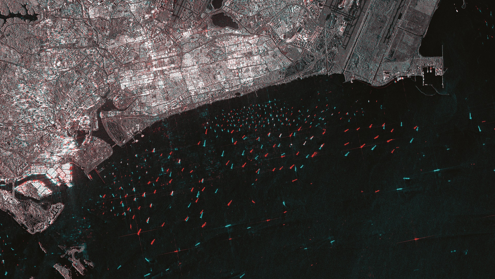
SEonSE
SEonSE (Smart Eyes on the SEas) is the e-GEOS new Maritime Surveillance Platform providing an innovative way to gain access to maritime domain awareness and tailored information, including early warning notifications, based on criteria established with the users. SEonSE to deliver Maritime Domain Awareness applications in Near Real Time, leverages on SEonSE-engine, the e-GEOS toolkit, for an advanced exploitation of Multimission and COSMO-SkyMed satellite data, integrating marine traffic data (e.g. SatAIS, AIS), meteo information and open-data satellites.
BRAINT
Image Intelligence analytical capability is continually improving as the technical performance of Earth Observation (EO) satellite missions evolve. In parallel to the proliferation of Open Source geospatial information, the intelligence community is set to experience a transformational sea change in capability, however as sources become more diverse and plentiful, so analysts need a platform to effectively and efficiently consolidate and synthesize it. braINT™ is the e-GEOS solution for imagery based actionable intelligence analysis, a modular environment for IMINT analysis and report generation. Based on a blended integration of proprietary algorithms braINT™ provides at its core a range of tailored operational workflows providing easy access to satellite imagery exploitation through simple steps to support analysts during each intelligence assessment phase.
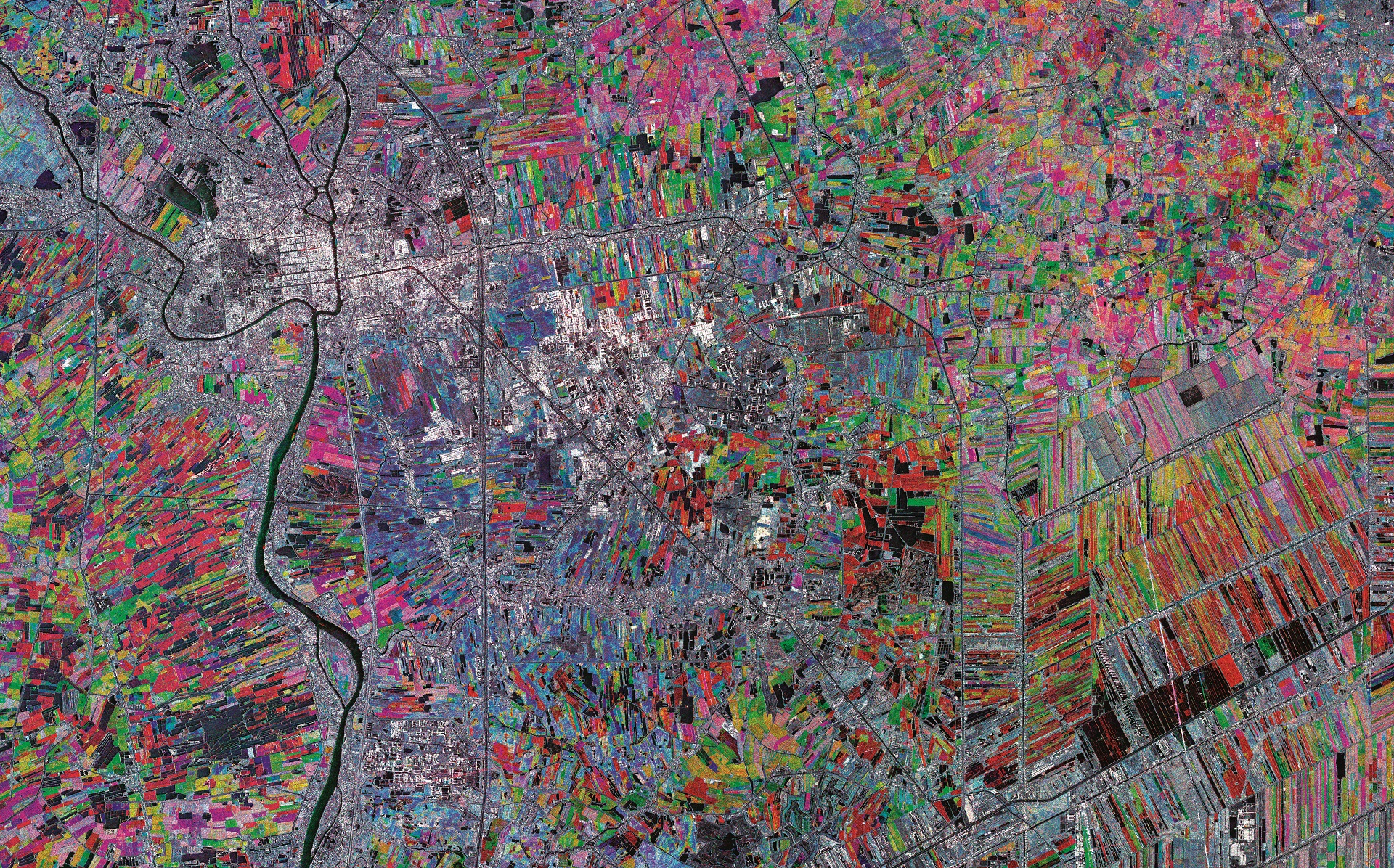
AGRIGEO
From precision farming to crop yield and damage estimation, the combined use of Earth observation data, Deep Learning and the supervision of photointerpreter create the usable feed for AGRIGEO the platform dedicated to the agricultural market segment. The innovation activities are an important asset of e-GEOS. Indeed, in this field, drones, smallsats and Sentinels are giving food for in-cloud processing and new algorithms allow unexpected analysis and new indicators suitable to support both public administration and farmers to better manage their own resources.
CLEOS
CLEOS, the digital infrastructure providing access to the whole spectrum of services, the new «digital market place», the tool for the transformation and digital use of the solutions of e-GEOS solutions and of our partners. CLEOS allows customers to take full advantage of the digital services of the platforms and developers to quickly define new workflows making use of the potential of advanced algorithms that implement innovative Artificial Intelligence techniques for information extraction.
Geodesy
Space Geodesy activities within e-GEOS date back to the beginning of 80’s when a Satellite Laser Ranging (SLR) station was installed at the Italian Space Agency’s Space Geodesy Center in Matera. We collect, analyze, interpret and archive data from the main space geodetic techniques: Satellite and Lunar Laser Ranging (SLR/LLR), Very Long Baseline Interferometry (VLBI) radio telescope, Global Navigation Satellite System (GNSS) receivers and absolute Gravimeter.
Copernicus, COSMO-SkyMed