
Our Missions & Programmes
Copernicus, Sentinel,CosmoSky-med
Geophysical Applications Processing s.r.l., innovative SME, born as a spin-off company of Politecnico di Bari, Italy, on February 2006, whose mission is to develop products, processes and services with technological and scientific value in the fields of satellite remote sensing, stereo vision and biomedical research, and related software/hardware technologies. The company is also able to provide scientific and technical trainings in the same fields.
The educational and research background of the spin-off company is based on scientific results achieved, over the last twenty years, by the Remote Sensing Group of the Department of Physics of Bari, and the Institute for high studies on Intelligent Automation Systems (ISSIA) of the National Council of Research (CNR) of Bari, in the framework of research projects funded by national and international space agencies (ASI, ESA, NASA) as well as by the European Commission.
Shareholders of GAP are Polytechnic of Bari, Planetek Italia s.r.l., SITAEL s.p.a., three professors of the Polytechnic of Bari, one professor of the University of Bari and four researchers of CNR.
GAP is member of the Association of Italian Small and Medium Aerospace Enterprises (AIPAS) and the Apulian Aerospace District, an association recognized on 2009 by a regional law that operates to reinforce and consolidate the competitiveness of regional aerospace products, in both national and international markets. The policy of the district aims on the one hand at reinforcing the integration and synergies between large and small & medium enterprises, and on the other hand at increasing and promoting its competence in research and vocational training throughout the entire country.
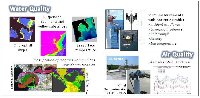
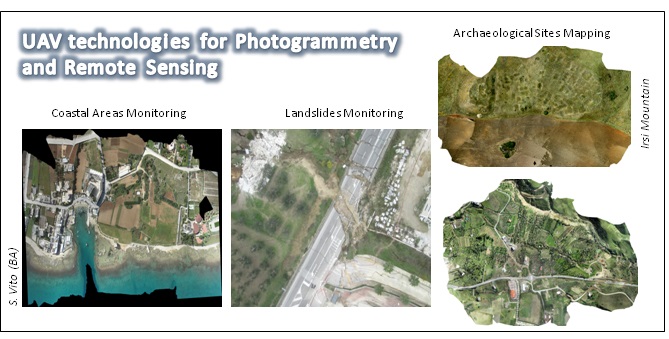
GAP offers a wide range of products and services for environmental monitoring and mapping through remote sensing techniques as well as in situ measurements. Here below the main areas of competence:
The long-term experience in the field of digital signal processing has enabled the transfer of GAP algorithms, developed for remote sensing, in other areas where advanced techniques are required for digital processing of data.
Via Amendola, 173 c/o Physics Department Bari BA 70126
Via Amendola, 173 c/o Physics Department Bari BA 70126
Filomena Ciola - Administration
+39 0805442180
mimma.ciola@gapsrl.eu
info@gapsrl.eu
http://www.gapsrl.eu/
GAP provides the following products and services characterized by high level of innovation and scientific/technological contents in the field of remote sensing and the related hardware and software technologies:
GAP expertise is based on Digital Signal Processing Techniques (Assembly, Fortran, C, Python, Matlab programming) applied to remote sensed data.
These techniques are used to:
For each of these products, GAP has:
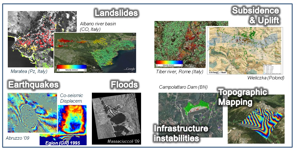
Of particular importance is the GAP expertise concerning the processing of data acquired by Synthetic Aperture Radars (SAR) with particular emphasis on Differential SAR Interferometry. This technique has been successfully applied to obtain topographic maps and study ground displacements with an accuracy of 1 mm/year. One of the major interests of the group is the assessment of EO-based methodologies to produce landslide early-warning maps, which rely on the detection of temporal changes of slope-related surface factors, associated with static landslide susceptibility mapping. The use of these advanced techniques applied to multi-temporal series of acquisitions is essential in this field of applications to detect small-scale phenomena such as slope and building instabilities using the Persistent/Distributed Scatterers (PS/DS) with sufficient spatial density. GAP has implemented a Multi Temporal Interferometry software, named SPINUA and based on PS/DS techniques, able to process multi-temporal series of acquisitions for the monitoring of building and terrain instabilities (seismic displacements, landslides, subsidence phenomena) even in scarcely urbanized areas. SPINUA software implements a proprietary version of the PS/DS techniques. It is able to process L, C and X-Band satellite data and has been successfully tested in many research activities as in the LEWIS (FP-V) and MORFEO (ASI) projects and in many case studies (Haiti, USA, China, Italy, Israel, Poland, Oman, etc.) concerning the monitoring of subsidence, landslides, earthquakes and infrastructures instabilities.
Copernicus, Sentinel,CosmoSky-med